Stormwater Mapping
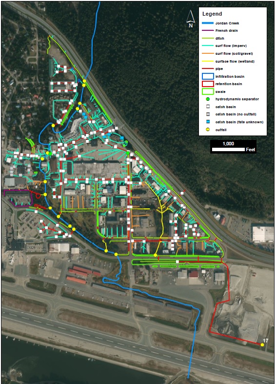
The Juneau Watershed Partnership mapped the stormwater infrastructure and flow paths in the lower Jordan Creek, Pederson Hill Creek, Lemon Creek and Vanderbilt Creek watersheds. In addition, the JWP identified target stormwater hotspots and made recommendations on how stormwater control and treatment could be improved. These mapping efforts were supported by the U.S. Fish and Wildlife Service (USFWS), the Alaska Dept. of Environmental Conservation (DEC), and the City and Borough of Juneau (CBJ). Lower Jordan Creek Stormwater Mapping Report (funding for project provided by the USFWS) Juneau Hydrography Report (funding for project provided by the DEC)
LEARN MORE:Why map stormwater? Mapping the stormwater infrastructure, flow paths and outfall locations provides a better u nderstanding of how stormwater moves through the watershed, which allows for improved stormwater control and treatment. The goal is to ultimately improve water quality and habitat for anadromous and resident fish, invertebrates, and wildlife. In addition, federal stormwater regulations for Municipal Separate Storm Sewer Systems (or MS4s) require municipal governments to have a map of their stormwater system. While Juneau is currently not regulated under this program, there is the potential that our community will be regulated in the future. In this way, our community is being proactive about stormwater management.
|
 |